
la Bourgade地形图
点击地图以显示海拔。
关于这张地图
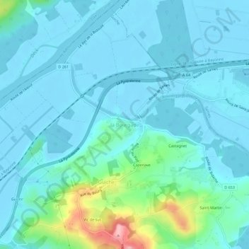
名称:la Bourgade地形图、海拔、地势。
平均海拔:23 米
最低海拔:-3 米
最高海拔:153 米
其他地形图
点击地图以查看其地形、其海拔和其地势。
Arette
France > Nouvelle-Aquitaine > Pyrénées-Atlantiques
Arette is a very large commune and has a land area of 92 km2. It is also mountainous (the La Pierre Saint-Martin ski resort is within its borders, for example) and its highest peak is the 2,315 m Soum Couy, which is situated not far from the 2,504 m Pic d'Anie, the highest peak in the western Pyrenees. From…
平均海拔:912 米
Biarritz
France > Nouvelle-Aquitaine > Pyrénées-Atlantiques
Biarritz appears as Bearids and Bearriz in 1150, Beiarridz in 1165, Bearriz and Beariz in 1170, Bearidz (1186), Bearriz and Beariz (12th century), lo port de Beiarriz and Bearridz in 1261 (cartulaire de Bayonne). Other forms include Beiarid (1199), Bearritz (1249), Beiarriz and Beiarrids (1261), Bearridz…
平均海拔:34 米
Bayonne
France > Nouvelle-Aquitaine > Pyrénées-Atlantiques
In the late Quaternary, the current topographic physiognomy was formed—i.e. a set of hills overlooking a swampy lowland. The promontory of Bassussarry–Marracq ultimately extended to the Labourdin foothills. The Grand Bayonne hill is an example. Similarly, on the right bank of the Nive, the heights of…
平均海拔:23 米
Anglet
France > Nouvelle-Aquitaine > Pyrénées-Atlantiques
In 1557, the Saint Léon church was demolished and transferred to its current location in 1564 in front of the current Hôtel de Ville (town hall) of Anglet. As Manex Goyhenetche points out in his book on Anglet, the city was then "the surrounding countryside of Bayonne", "densely populated rural suburb of…
平均海拔:23 米
Accous
France > Nouvelle-Aquitaine > Pyrénées-Atlantiques
Le Bois d'Arapoup is attested in 1863 in the Topographical Dictionary.
平均海拔:1,332 米
Lescun
France > Nouvelle-Aquitaine > Pyrénées-Atlantiques
It is at an elevation of approximately 900 metres (3,000 feet) in a grand cirque.
平均海拔:1,300 米
Biarritz
France > Nouvelle-Aquitaine > Pyrénées-Atlantiques
Biarritz appears as Bearids and Bearriz in 1150, Beiarridz in 1165, Bearriz and Beariz in 1170, Bearidz (1186), Bearriz and Beariz (12th century), lo port de Beiarriz and Bearridz in 1261 (cartulaire de Bayonne). Other forms include Beiarid (1199), Bearritz (1249), Beiarriz and Beiarrids (1261), Bearridz…
平均海拔:34 米
Pau
France > Nouvelle-Aquitaine > Pyrénées-Atlantiques
The city, located at an average altitude of 200 metres (660 ft), is crossed by the Gave de Pau, where a ford gave passage to the Pyrenees. Gave is the name given to a torrent in the Pyrenees. The Gave de Pau, which becomes a torrent when mountain snow melts, takes its source in the Cirque de Gavarnie and is…
平均海拔:205 米
Bayonne
France > Nouvelle-Aquitaine > Pyrénées-Atlantiques
In the late Quaternary, the current topographic physiognomy was formed—i.e. a set of hills overlooking a swampy lowland. The promontory of Bassussarry–Marracq ultimately extended to the Labourdin foothills. The Grand Bayonne hill is an example. Similarly, on the right bank of the Nive, the heights of…
平均海拔:23 米
Biarritz
France > Nouvelle-Aquitaine > Pyrénées-Atlantiques
Biarritz appears as Bearids and Bearriz in 1150, Beiarridz in 1165, Bearriz and Beariz in 1170, Bearidz (1186), Bearriz and Beariz (12th century), lo port de Beiarriz and Bearridz in 1261 (cartulaire de Bayonne). Other forms include Beiarid (1199), Bearritz (1249), Beiarriz and Beiarrids (1261), Bearridz…
平均海拔:34 米
Lescun
France > Nouvelle-Aquitaine > Pyrénées-Atlantiques
It is at an elevation of approximately 900 metres (3,000 feet) in a grand cirque.
平均海拔:1,300 米
Biarritz
France > Nouvelle-Aquitaine > Pyrénées-Atlantiques > Biarritz
Biarritz appears as Bearids and Bearriz in 1150, Beiarridz in 1165, Bearriz and Beariz in 1170, Bearidz (1186), Bearriz and Beariz (12th century), lo port de Beiarriz and Bearridz in 1261 (cartulaire de Bayonne). Other forms include Beiarid (1199), Bearritz (1249), Beiarriz and Beiarrids (1261), Bearridz…
平均海拔:39 米