
Labu Estate地形图
点击地图以显示海拔。
关于这张地图
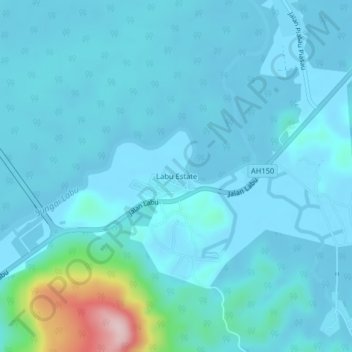
名称:Labu Estate地形图、海拔、地势。
地点:Labu Estate, Temburong District, PB1151, Brunei (4.74394 115.16494 4.78394 115.20494)
平均海拔:29 米
最低海拔:1 米
最高海拔:277 米
其他地形图
点击地图以查看其地形、其海拔和其地势。
Belait District
The South China Sea borders Belait District to the north, Tutong District to the northeast, and Sarawak, Malaysia to the west and south. The district's lowlands are steep and below an elevation of 91 metres (299 ft). Areas along the shore, which are mostly characterised by marshy plains with slender alluvial…
平均海拔:45 米