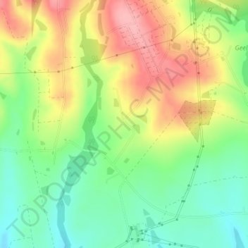
点击地图以显示海拔。
名称:Geelhoutboom地形图、海拔、地势。
地点:Geelhoutboom, George Ward 22, George Local Municipality, George, Western Cape, South Africa (-33.95769 22.32514 -33.93769 22.34514)
平均海拔:250 米
最低海拔:193 米
最高海拔:320 米
点击地图以查看其地形、其海拔和其地势。
South Africa > Western Cape > George
平均海拔:262 米
平均海拔:132 米
平均海拔:14 米
平均海拔:361 米
平均海拔:95 米
平均海拔:284 米
平均海拔:105 米
平均海拔:636 米