
Kampung Janda Baik地形图
点击地图以显示海拔。
Kampung Janda Baik
Before Janda Baik was founded in 1930, the area was primarily inhabited by Orang Asli tribes. The village was founded when some residents moved from Bentong to an area with a higher elevation due to the 1926 floods that affected Bentong and other low elevation areas. The earliest founders for this village are Haji Deris, Haji Kadir, and Haji Yasir, who built a hut and stayed in the area for almost a week before others start to populate the area. The village was originally given the name Kampung Tiga Haji to refer to the three early settlers.
关于这张地图
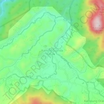
名称:Kampung Janda Baik地形图、海拔、地势。
地点:Kampung Janda Baik, Bentong, Pahang, 28750, Malaysia (3.30276 101.82868 3.34276 101.86868)
平均海拔:501 米
最低海拔:351 米
最高海拔:895 米