
Vijayawada地形图
点击地图以显示海拔。
Vijayawada
Vijayawada lies on the banks of Krishna river, covered by hills and canals. and at an altitude of 11 m (36 ft) above sea level. Three canals originating from the north side of the Prakasam Barrage reservoir — Eluru, Bandar, and Ryves — flow through the city.
关于这张地图
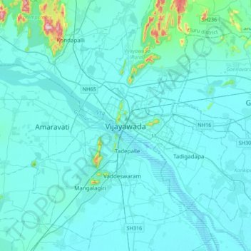
名称:Vijayawada地形图、海拔、地势。
地点:Vijayawada, NTR, Andhra Pradesh, 520001, India (16.35153 80.45605 16.67153 80.77605)
平均海拔:37 米
最低海拔:7 米
最高海拔:448 米