Cordova地形图
点击地图以显示海拔。
关于这张地图
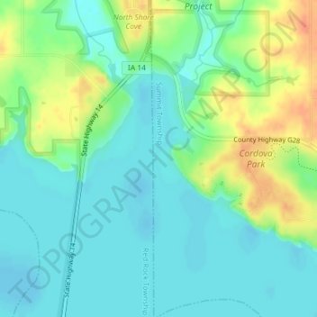
名称:Cordova地形图、海拔、地势。
地点:Cordova, Summit Township, Marion County, Iowa, United States (41.41756 -93.10966 41.43756 -93.08966)
平均海拔:235 米
最低海拔:220 米
最高海拔:265 米
其他地形图
点击地图以查看其地形、其海拔和其地势。

点击地图以显示海拔。
名称:Cordova地形图、海拔、地势。
地点:Cordova, Summit Township, Marion County, Iowa, United States (41.41756 -93.10966 41.43756 -93.08966)
平均海拔:235 米
最低海拔:220 米
最高海拔:265 米
点击地图以查看其地形、其海拔和其地势。