
Black Jack Battlefield地形图
点击地图以显示海拔。
关于这张地图
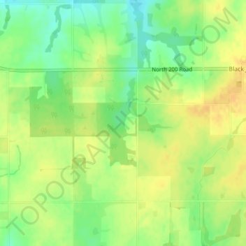
名称:Black Jack Battlefield地形图、海拔、地势。
平均海拔:332 米
最低海拔:315 米
最高海拔:343 米
其他地形图
点击地图以查看其地形、其海拔和其地势。
Lawrence
United States > Kansas > Douglas County
Lawrence is located at coordinates 38.9716689, -95.2352501 in the state of Kansas, approximately 25 miles (40 kilometers) east of Topeka, and 35 mi (56 km) west of Kansas City, Kansas. Though Lawrence has a designated elevation of 866 feet (264 m), the highest elevation is Mount Oread on the University of…
平均海拔:265 米
Lawrence
United States > Kansas > Douglas County
Lawrence is located approximately 25 miles (40 kilometers) east of Topeka, and 35 mi (56 km) west of Kansas City, Kansas. Though Lawrence has a designated elevation of 866 feet (264 m), the highest elevation is Mount Oread on the University of Kansas campus with an elevation of 1,020 feet (310 m).
平均海拔:265 米
Lawrence
United States > Kansas > Douglas County
Lawrence is located at coordinates 38.9716689, -95.2352501 in the state of Kansas, approximately 25 miles (40 kilometers) east of Topeka, and 35 mi (56 km) west of Kansas City, Kansas. Though Lawrence has a designated elevation of 866 feet (264 m), the highest elevation is Mount Oread on the University of…
平均海拔:265 米