
Hunt地形图
点击地图以显示海拔。
关于这张地图
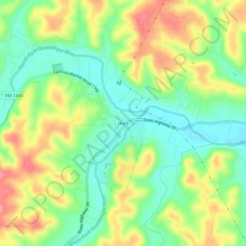
名称:Hunt地形图、海拔、地势。
地点:Hunt, Kerr County, Texas, 78024, United States (30.04955 -99.35521 30.08955 -99.31521)
平均海拔:572 米
最低海拔:527 米
最高海拔:632 米
其他地形图
点击地图以查看其地形、其海拔和其地势。
Kerrville
United States > Texas > Kerr County
Kerrville is characterized by a diverse and rugged topography. Nestled along the Guadalupe River, it sits at an elevation averaging 1,600 feet above sea level, with varying terrain that includes gentle hills, steep slopes, and flat river valleys. This area features numerous limestone hills, characteristic of…
平均海拔:545 米