Auckland地形图
互动地图
点击地图以显示海拔。
关于这张地图
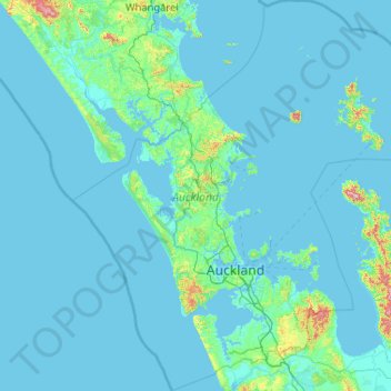
名称:Auckland地形图、海拔、地势。
地点:Auckland, 紐西蘭/新西兰 (-37.36447 173.89633 -35.69839 175.90322)
平均海拔:30 米
最低海拔:-1 米
最高海拔:836 米
海拔高的地點是惠靈頓山(mount wellington),海拔196米,年均降雨量約1200毫米。
其他地形图
点击地图以查看其地形、其海拔和其地势。
Lake Surprise
紐西蘭/新西兰 > Manawatū-Whanganui > Ruapehu District
Lake Surprise, Ruapehu District, Manawatū-Whanganui, 紐西蘭/新西兰
平均海拔:1,339 米
新普利茅斯
紐西蘭/新西兰 > Taranaki > New Plymouth District
新普利茅斯, New Plymouth District, Taranaki, 4310, 紐西蘭/新西兰
平均海拔:92 米
Calypso Bay / Ōtamarau Bay
Calypso Bay / Ōtamarau Bay, Waiheke, Auckland, 紐西蘭/新西兰
平均海拔:5 米
Shelly Bay
紐西蘭/新西兰 > Bay of Plenty > Western Bay of Plenty District > Pios Beach
Shelly Bay, Pios Beach, Western Bay of Plenty District, Bay of Plenty, 紐西蘭/新西兰
平均海拔:3 米
Rolleston
紐西蘭/新西兰 > Canterbury > Selwyn District
Rolleston, Selwyn District, Canterbury, 7643, 紐西蘭/新西兰
平均海拔:54 米
Akaroa
紐西蘭/新西兰 > Canterbury > Christchurch City > Banks Peninsula Community
Akaroa, Banks Peninsula Community, Christchurch City, Canterbury, 紐西蘭/新西兰
平均海拔:191 米
箭镇
紐西蘭/新西兰 > Otago > Queenstown-Lakes District
箭镇, Queenstown-Lakes District, Otago, 9302, 紐西蘭/新西兰
平均海拔:671 米
Halswell-Hornby-Riccarton Community
紐西蘭/新西兰 > Canterbury > Christchurch City
Halswell-Hornby-Riccarton Community, Christchurch City, Canterbury, 紐西蘭/新西兰
平均海拔:49 米
Waitomo Caves
紐西蘭/新西兰 > Waikato > Waitomo District
Waitomo Caves, Waitomo District, Waikato, 3981, 紐西蘭/新西兰
平均海拔:98 米
哈斯丁
紐西蘭/新西兰 > Hawke's Bay > Hastings District
哈斯丁, Hastings District, Hawke's Bay, 4122, 紐西蘭/新西兰
平均海拔:68 米
皇后镇
紐西蘭/新西兰 > Otago > Queenstown-Lakes District
皇后镇, Queenstown-Lakes District, Otago, 9348, 紐西蘭/新西兰
平均海拔:592 米
Waitakere or Nile River
紐西蘭/新西兰 > West Coast > Buller District
Waitakere or Nile River, Buller District, West Coast, 紐西蘭/新西兰
平均海拔:292 米
普罗鲁阿
紐西蘭/新西兰 > 惠灵顿 / 惠靈頓 / 威靈頓 > Porirua City
普罗鲁阿, Porirua City, 惠灵顿 / 惠靈頓 / 威靈頓, 5022, 紐西蘭/新西兰
平均海拔:115 米