
West Midlands地形图
点击地图以显示海拔。
关于这张地图
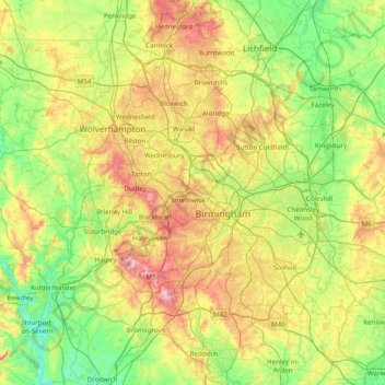
名称:West Midlands地形图、海拔、地势。
平均海拔:113 米
最低海拔:15 米
最高海拔:307 米
其他地形图
点击地图以查看其地形、其海拔和其地势。
Holbech's Wood
United Kingdom > England > Warwickshire > North Warwickshire > Fillongley CP
平均海拔:140 米
Big Clowes Wood
United Kingdom > England > Warwickshire > Stratford-on-Avon > Tanworth in Arden CP
平均海拔:152 米
Sutton-under-Brailes
United Kingdom > England > Warwickshire > Stratford-on-Avon > Stourton
平均海拔:125 米
Oversley Wood
United Kingdom > England > Warwickshire > Stratford-on-Avon > Alcester > Exhall
平均海拔:64 米
Curdworth Locks
United Kingdom > England > Warwickshire > North Warwickshire > Kingsbury > Curdworth CP
平均海拔:80 米
Pillerton Hersey
United Kingdom > England > Warwickshire > Stratford-on-Avon > Pillerton Hersey
平均海拔:92 米
Pooley Country Park
United Kingdom > England > Warwickshire > North Warwickshire > Polesworth
平均海拔:76 米
Upper Quinton
United Kingdom > England > Warwickshire > Stratford-on-Avon > Lower Quinton > Upper Quinton
平均海拔:70 米