
Weybridge地形图
点击地图以显示海拔。
关于这张地图
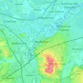
名称:Weybridge地形图、海拔、地势。
平均海拔:21 米
最低海拔:7 米
最高海拔:82 米
其他地形图
点击地图以查看其地形、其海拔和其地势。
Esher
United Kingdom > England > Surrey > Elmbridge
Esher is an outlying suburb of London, close to the London–Surrey border; with Esher Commons at its southern end, the town marks one limit of the Greater London Built-Up Area. Esher has a linear commercial high street and is otherwise suburban in density, with varying elevations, few high rise buildings and…
平均海拔:21 米