
Cinder Cone地形图
点击地图以显示海拔。
关于这张地图
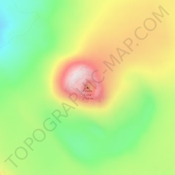
名称:Cinder Cone地形图、海拔、地势。
地点:Cinder Cone, Lake and Peninsula, Alaska, United States (56.19573 -159.39031 56.19583 -159.39021)
平均海拔:1,843 米
最低海拔:1,607 米
最高海拔:2,128 米
其他地形图
点击地图以查看其地形、其海拔和其地势。
Aniakchak National Monument
United States > Alaska > Lake and Peninsula
The national monument is centered on the 6-mile (9.7 km) diameter crater of ancient Mount Aniakchak, which was destroyed and the resulting crater formed during a caldera collapse event about 3,700 years ago. The original mountain, about 7,000 feet (2,100 m) tall, collapsed into its magma chamber, leaving an…
平均海拔:376 米