
Staten Island地形图
点击地图以显示海拔。
关于这张地图
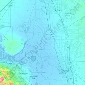
名称:Staten Island地形图、海拔、地势。
平均海拔:24 米
最低海拔:-8 米
最高海拔:1,093 米
其他地形图
点击地图以查看其地形、其海拔和其地势。
Grass Valley
United States of America > California > Grass Valley
The city of Grass Valley is the largest city in the western region of Nevada County, California, United States. Situated at roughly 2,500 feet (760 m) elevation in the western foothills of the Sierra Nevada mountain range, this historic northern Gold Country city is 57 miles (92 km) by car from the state…
平均海拔:777 米
San Francisco
United States of America > California
Because of its sharp topography and maritime influences, San Francisco exhibits a multitude of distinct microclimates. The high hills in the geographic center of the city are responsible for a 20% variance in annual rainfall between different parts of the city. They also protect neighborhoods directly to their…
平均海拔:57 米
Riverside
United States of America > California > Riverside
Riverside is the 59th largest city in the United States, the 12th largest city in California, and the largest city in California's Inland Empire metro area. According to the United States Census Bureau, the city has a total area of 81.4 square miles (210.8 km2), of which 81.1 square miles (210 km2) is land and…
平均海拔:351 米
Clearlake
United States of America > California > Clearlake
Clearlake is a city in Lake County, California, United States. Clearlake is 4.5 miles (7.2 km) north-northwest of Lower Lake, at an elevation of 1417 feet (432 m). As of the 2010 census, the city had a total population of 15,250, up from 13,142 in 2000. It takes its name from Clear Lake.
平均海拔:474 米
Salton Sea
United States of America > California > Salton City
The lake occupies the lowest elevations of the Salton Sink in the Colorado Desert of Imperial and Riverside counties in Southern California. Its surface is 236.0 ft (71.9 m) below sea level as of January 2018. The deepest point of the sea is 5 ft (1.5 m) higher than the lowest point of Death Valley. The sea is…
平均海拔:17 米
Rancho Santa Fe
United States of America > California > Rancho Santa Fe
The climate of Rancho Santa Fe is, for the most part, typical of the San Diego metropolitan area though its higher elevation and inland location lends itself to larger temperature variations.
平均海拔:68 米
Kelseyville
United States of America > California > Kelseyville
Kelseyville is a census-designated place (CDP) in Lake County, California, United States. Kelseyville is located 6 miles (9.7 km) southeast of Lakeport, at an elevation of 1,384 feet (422 m). The population was 3,353 at the 2010 census, up from 2,928 at the 2000 census.
平均海拔:462 米