
Mount Katmai地形图
点击地图以显示海拔。
Mount Katmai
Mount Katmai (Russian: Катмай) is a large active stratovolcano (composite volcano) on the Alaska Peninsula in southern Alaska, located within Katmai National Park and Preserve. It is about 6.3 miles (10 km) in diameter with a central lake-filled caldera about two by three miles (3.2 by 4.8 km) in size, formed during the Novarupta eruption of 1912. The caldera rim reaches a maximum elevation of 6,716 feet (2,047 m). In 1975 the surface of the crater lake was at an elevation of about 4,220 feet (1,286 m), and the estimated elevation of the caldera floor is about 3,400 ft (1,040 m). The mountain is located in Kodiak Island Borough, very close to its border with Lake and Peninsula Borough. The volcano has caused ten known fatalities due to gas exposure.
关于这张地图
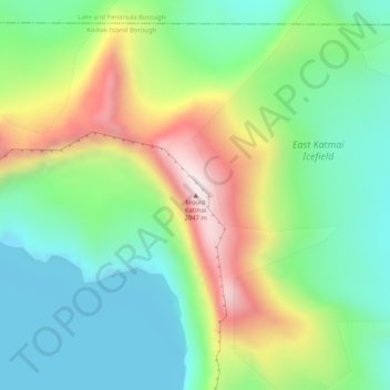
名称:Mount Katmai地形图、海拔、地势。
地点:Mount Katmai, Kodiak Island Borough, Alaska, United States (58.27884 -154.95338 58.27894 -154.95328)
平均海拔:1,515 米
最低海拔:1,274 米
最高海拔:1,968 米
其他地形图
点击地图以查看其地形、其海拔和其地势。