
Ebenezer地形图
点击地图以显示海拔。
关于这张地图
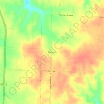
名称:Ebenezer地形图、海拔、地势。
地点:Ebenezer, Greene County, Missouri, United States (37.32032 -93.32713 37.36032 -93.28713)
平均海拔:380 米
最低海拔:346 米
最高海拔:400 米
其他地形图
点击地图以查看其地形、其海拔和其地势。
Springfield
United States > Missouri > Greene County
Springfield is situated on a gently rolling plateau at an average elevation of approximately 1,310 feet (400 meters) above sea level. The region is characterized by a mix of flatlands and gradual slopes that rise toward the nearby Ozark Mountains, which can be found to the south and east. The local terrain…
平均海拔:389 米
Strafford
United States > Missouri > Greene County
According to the United States Census Bureau, the city has a total area of 2.63 square miles (6.81 km2), all land. USGS Department of the Interior Original Survey 1838 and USGS Topographical Maps show the town along the White River Road that became the Telegraph Road to Saint Louis.
平均海拔:437 米