Highland地形图
点击地图以显示海拔。
关于这张地图
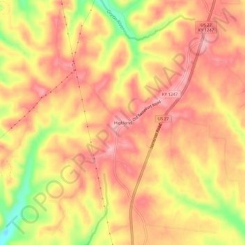
名称:Highland地形图、海拔、地势。
地点:Highland, Lincoln County, Kentucky, United States (37.40813 -84.67383 37.44813 -84.63383)
平均海拔:395 米
最低海拔:309 米
最高海拔:436 米
其他地形图
点击地图以查看其地形、其海拔和其地势。

点击地图以显示海拔。
名称:Highland地形图、海拔、地势。
地点:Highland, Lincoln County, Kentucky, United States (37.40813 -84.67383 37.44813 -84.63383)
平均海拔:395 米
最低海拔:309 米
最高海拔:436 米
点击地图以查看其地形、其海拔和其地势。