
Dyke地形图
点击地图以显示海拔。
关于这张地图
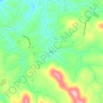
名称:Dyke地形图、海拔、地势。
地点:Dyke, Gilmer County, Georgia, 30636, United States (34.57981 -84.43159 34.61981 -84.39159)
平均海拔:508 米
最低海拔:435 米
最高海拔:633 米
其他地形图
点击地图以查看其地形、其海拔和其地势。
Ellijay
United States > Georgia > Gilmer County
Ellijay sits within a rugged and mountainous terrain, characterized by rolling hills, deep valleys, and ridgelines that are part of the larger Appalachian Mountain system. The area has an average elevation of about 1,390 feet, though nearby peaks like Walnut Mountain rise to elevations over 2,500 feet. The…
平均海拔:424 米
Ellijay
United States > Georgia > Gilmer County
Ellijay lies within the Humid subtropical climate zone along with the majority of the rest of the Southeastern United States. The highest elevations in the surrounding region reside in the oceanic climate. Ellijay enjoys cool winters and warm summers, but neither would be considered extreme due to its slightly…
平均海拔:424 米
Ellijay
United States > Georgia > Gilmer County
Ellijay lies within the Humid subtropical climate zone along with the majority of the rest of the southeastern United States. The highest elevations in the surrounding region reside in the Subtropical highland climate. Ellijay enjoys cool winters and warm summers, but neither would be considered extreme thanks…
平均海拔:424 米