
Shoa Robit地形图
点击地图以显示海拔。
Shoa Robit
Shewa Robit (Amharic: ሸዋ ሮቢት)also known as Robi, Shah Robit, Shoa Robit or Robit is a town in north-central Ethiopia. Located in the North Shewa Zone of the Amhara Region, this town has a longitude and latitude of 10°00′N 39°54′E / 10.000°N 39.900°E / 10.000; 39.900 with an elevation of 1280 meters above sea level. Shewa Robit holds its market on Tuesdays. Ethiopia's largest prison is in this town.
关于这张地图
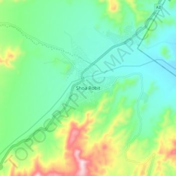
名称:Shoa Robit地形图、海拔、地势。
平均海拔:1,360 米
最低海拔:1,205 米
最高海拔:1,752 米
其他地形图
点击地图以查看其地形、其海拔和其地势。
Simien Mountains National Park
The vegetation is mixed with African alpine forests, wilderness forests and alpine vegetation. High altitude areas include montane savannah and tree heath (Erica arborea), giant lobelia (Lobelia rhynchopetalum), yellow primrose (Primula verticillata), everlastings (Helichrysum spp.), a lady's mantle…
平均海拔:2,337 米
Awi Agew
Topographically speaking, Agaw Awi is relatively flat and fertile, whose elevations vary from 1,800 to 3,100 m above sea level, with an average altitude of about 2,300 m. The Zone is crossed by about nine permanent rivers which drain into the Abay (or Blue Nile); other water features include two crater lakes,…
平均海拔:1,640 米
Simien Mountains National Park
The vegetation is mixed with African alpine forests, wilderness forests and alpine vegetation. High altitude areas include montane savannah and tree heath (Erica arborea), giant lobelia (Lobelia rhynchopetalum), yellow primrose (Primula verticillata), everlastings (Helichrysum spp.), A lady's mantle…
平均海拔:2,337 米
Bahir Dar Special Zone
Bahir Dar is located at the exit of the Abbay from Lake Tana at an altitude of 1,820 metres (5,970 ft) above sea level. The city is located approximately 578 km north-northwest of Addis Ababa. The Lake Tana region is a UNESCO Biosphere Reserve since 2015.
平均海拔:1,794 米
Bahir Dar Special Zone
Bahir Dar is located at the exit of the Abbay from Lake Tana at an altitude of 1,820 metres (5,970 ft) above sea level. The city is located approximately 578 km north-northwest of Addis Ababa. The Lake Tana region is a UNESCO Biosphere Reserve since 2015.
平均海拔:1,794 米
Awi Agew
Topographically speaking, Agaw Awi is relatively flat and fertile, whose elevations vary from 1,800 to 3,100 m above sea level, with an average altitude of about 2,300 m. The Zone is crossed by about nine permanent rivers which drain into the Abay (or Blue Nile); other water features include two crater lakes,…
平均海拔:1,640 米