
Eagle Rock地形图
点击地图以显示海拔。
关于这张地图
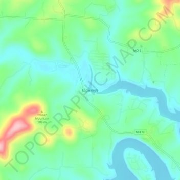
名称:Eagle Rock地形图、海拔、地势。
地点:Eagle Rock, Barry County, Missouri, 65641, United States (36.52812 -93.77436 36.56812 -93.73436)
平均海拔:322 米
最低海拔:276 米
最高海拔:445 米
其他地形图
点击地图以查看其地形、其海拔和其地势。
Purdy
United States > Missouri > Barry County
US Department of the Interior Original Surveys and USGS Topographical map showing the Butterfield Overland Mail Route
平均海拔:445 米
Purdy
United States > Missouri > Barry County
US Department of the Interior Original Surveys and USGS Topographical map showing the Butterfield Overland Mail Route
平均海拔:445 米