
Taplejung地形图
点击地图以显示海拔。
Taplejung
Geographically Taplejung is a mountainous district where the world's third highest peak Kanchenjunga (8586 m) is located. It is situated at elevation ranging from 670 metres (2,200 ft) to 8,586 metres (28,169 ft) from sea level.
关于这张地图
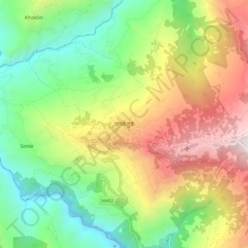
名称:Taplejung地形图、海拔、地势。
地点:Taplejung, Phungling, Taplejung, Koshi Province, 57500, Nepal (27.31870 87.63273 27.39870 87.71273)
平均海拔:1,410 米
最低海拔:556 米
最高海拔:2,666 米
其他地形图
点击地图以查看其地形、其海拔和其地势。