
Hobart地形图
点击地图以显示海拔。
关于这张地图
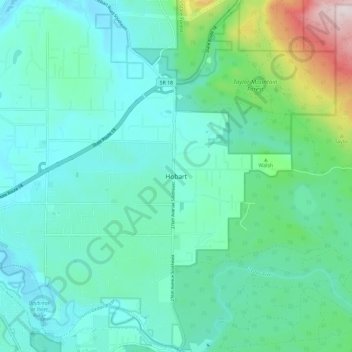
名称:Hobart地形图、海拔、地势。
地点:Hobart, King County, Washington, United States (47.37440 -122.01233 47.45440 -121.93233)
平均海拔:235 米
最低海拔:106 米
最高海拔:782 米
其他地形图
点击地图以查看其地形、其海拔和其地势。
Lake Marcel
United States > Washington > King County
Lake Marcel is at an altitude of 295 feet (90 m) above sea level. The lake sits in a bowl at the top of Stillwater Hill on the east side of the Snoqualmie Valley, north of Carnation. It has two main areas of water connected by a channel, and several peninsular features make an extensive shoreline around the…
平均海拔:110 米
Snoqualmie River
United States > Washington > King County
The Middle Fork Valley is a popular recreational area since it is accessible during the winter due to its low altitude and close proximity to Seattle. For many years the Middle Fork Road extended 24 miles to Hardscrabble Creek, but was gated at Dingford Creek in June 2007, 18 miles in. The gate at Dingford…
平均海拔:212 米
Clyde Hill
United States > Washington > King County
The top elevation is close to 375 feet. There are approximately 21 miles of public roadways in Clyde Hill.
平均海拔:48 米
Mercer Island
United States > Washington > King County > Mercer Island
Mercer Island City Hall is located at 47°34′39″N 122°12′43.2″W / 47.57750°N 122.212000°W / 47.57750; -122.212000 (47.5775, -122.212). The peak elevation in the city is about 338 feet (103 m), near the center of the island.
平均海拔:39 米