
Fatima地形图
点击地图以显示海拔。
关于这张地图
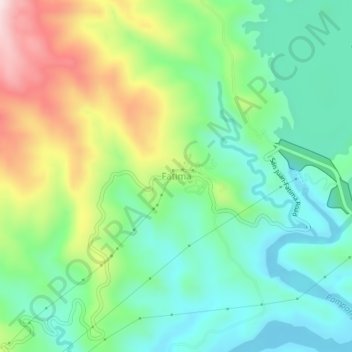
名称:Fatima地形图、海拔、地势。
地点:Fatima, Pantabangan, Nueva Ecija, Central Luzon, Philippines (15.79210 121.07389 15.83210 121.11389)
平均海拔:270 米
最低海拔:129 米
最高海拔:554 米
其他地形图
点击地图以查看其地形、其海拔和其地势。
Pantabangan Dam
Philippines > Nueva Ecija > Pantabangan > Fatima
The dam is a 107 m (351 ft) tall and 1,615 m (5,299 ft) long embankment-type with 12,000,000 cu yd (9,174,658 m3) of homogeneous earth-fill and an impervious core. The crest of the dam is 12 m (39 ft) wide while the widest part of its base is 535 m (1,755 ft). The dam's crest sits at an elevation of 232 m (761…
平均海拔:210 米