
Vanzant地形图
点击地图以显示海拔。
关于这张地图
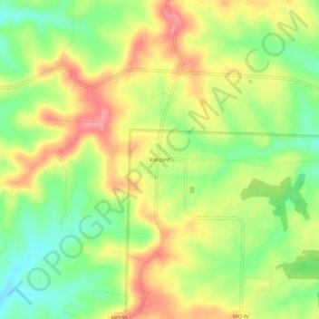
名称:Vanzant地形图、海拔、地势。
地点:Vanzant, Douglas County, Missouri, United States (36.94978 -92.32294 36.98978 -92.28294)
平均海拔:352 米
最低海拔:309 米
最高海拔:395 米
其他地形图
点击地图以查看其地形、其海拔和其地势。
Ava
United States > Missouri > Douglas County
Ava is located in the southern portion of the Missouri Ozarks within the southern escarpment of the Salem Plateau. The lakes of the White River basin of northern Arkansas and southern Missouri lie to the south. The town is at the intersection of Missouri highways 5, 14 and 76. Mansfield is 13 miles to the…
平均海拔:392 米