
Cosgrove地形图
点击地图以显示海拔。
关于这张地图
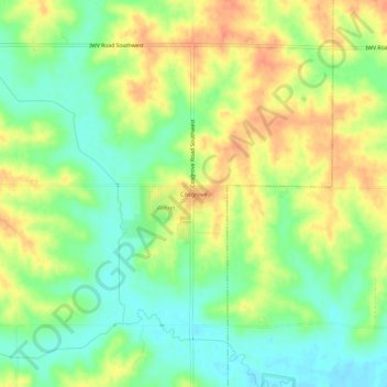
名称:Cosgrove地形图、海拔、地势。
地点:Cosgrove, Johnson County, Iowa, 52244, United States (41.62279 -91.75573 41.66279 -91.71573)
平均海拔:228 米
最低海拔:206 米
最高海拔:251 米
其他地形图
点击地图以查看其地形、其海拔和其地势。
Iowa City
United States > Iowa > Johnson County
The elevation at the Iowa City Municipal Airport is 668 ft (204 m) above sea level.
平均海拔:216 米
Iowa City
United States > Iowa > Johnson County
The elevation at the Iowa City Municipal Airport is 668 ft (203.6 m) above sea level.
平均海拔:216 米
Iowa City
United States > Iowa > Johnson County
The elevation at the Iowa City Municipal Airport is 668 ft (204 m) above sea level.
平均海拔:216 米
Iowa City
United States > Iowa > Johnson County
The elevation at the Iowa City Municipal Airport is 668 ft (204 m) above sea level.
平均海拔:216 米
North Liberty
United States > Iowa > Johnson County
North Liberty is located on the Iowan erosion surface. Drivers on I-380 experience an abrupt transition from the muted topography of the Iowan surface to the rolling hills of the Southern Iowa drift plain, four miles south of North Liberty.
平均海拔:235 米