
Wasagaming地形图
点击地图以显示海拔。
Wasagaming
Wasagaming has a subarctic climate (Dfc) due to its northerly location and high elevation. Winters are extremely cold and relatively dry with little chance of a mid-winter thaw. The average annual temperature is 0.7 °C (33.3 °F). Annual precipitation is 488 mm (19.2 in).
关于这张地图
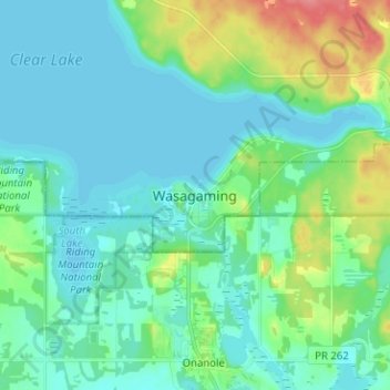
名称:Wasagaming地形图、海拔、地势。
平均海拔:630 米
最低海拔:615 米
最高海拔:683 米
其他地形图
点击地图以查看其地形、其海拔和其地势。
Riding Mountain National Park
Canada > Manitoba > Unorganized Division No. 17 > Wasagaming
Riding Mountain Biosphere Reserve covers 15,000 square kilometers of land in South-western Manitoba, with the core area, Riding Mountain National Park (RMNP), covering nearly 3,000 square kilometers. It is some 300 km northwest of Winnipeg, Manitoba. The local climate is cool and moist due to a higher…
平均海拔:488 米