Flat Rock地形图
点击地图以显示海拔。
关于这张地图
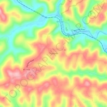
名称:Flat Rock地形图、海拔、地势。
地点:Flat Rock, Rockcastle County, Kentucky, 40460, United States (37.34092 -84.29105 37.38092 -84.25105)
平均海拔:356 米
最低海拔:271 米
最高海拔:432 米
其他地形图
点击地图以查看其地形、其海拔和其地势。

点击地图以显示海拔。
名称:Flat Rock地形图、海拔、地势。
地点:Flat Rock, Rockcastle County, Kentucky, 40460, United States (37.34092 -84.29105 37.38092 -84.25105)
平均海拔:356 米
最低海拔:271 米
最高海拔:432 米
点击地图以查看其地形、其海拔和其地势。