
Fort Worth地形图
点击地图以显示海拔。
关于这张地图
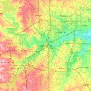
名称:Fort Worth地形图、海拔、地势。
地点:Fort Worth, Tarrant County, Texas, 76102, United States (32.59318 -97.49275 32.91318 -97.17275)
平均海拔:202 米
最低海拔:139 米
最高海拔:279 米
其他地形图
点击地图以查看其地形、其海拔和其地势。
Benbrook Lake
United States > Texas > Tarrant County > Fort Worth
Construction of Benbrook dam began in May 1947, and was practically completed when floodgates were closed and deliberate impoundment was begun in September 1952. The cost to build the lake was $14.5 million ($112 million in 2007 dollars). The rolled-earth embankment is 9,130 feet (2,783 m) in length, including…
平均海拔:228 米