
Hoghton Bottoms地形图
点击地图以显示海拔。
关于这张地图
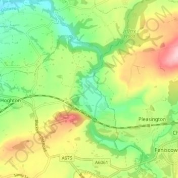
名称:Hoghton Bottoms地形图、海拔、地势。
平均海拔:105 米
最低海拔:30 米
最高海拔:210 米
其他地形图
点击地图以查看其地形、其海拔和其地势。
Coppull
United Kingdom > England > Lancashire > Chorley
The settlement has an Anglo Saxon name describing its topography derived from the Old English copp a hill top and hyll a hill. The township was variously recorded as Cophull and Cophulle in 1277, Copphull in 1351, Copthull in 1374 and Coppull from 1444.
平均海拔:80 米
Coppull
United Kingdom > England > Lancashire > Chorley
The settlement has an Anglo Saxon name describing its topography derived from the Old English copp a hill top and hyll a hill. The township was variously recorded as Cophull and Cophulle in 1277, Copphull in 1351, Copthull in 1374 and Coppull from 1444.
平均海拔:82 米