
Cambridge地形图
点击地图以显示海拔。
Cambridge
The city, like most of the UK, has a maritime climate highly influenced by the Gulf Stream. Located in the driest region of Britain, Cambridge's rainfall averages around 570 mm (22.44 in) per year, around half the national average, The driest recent year was in 2011 with 380.4 mm (14.98 in) of rain at the Botanic Garden and 347.2 mm (13.67 in) at the NIAB site. This is just below the semi-arid precipitation threshold for the area, which is 350mm of annual precipitation. Conversely, 2012 was the wettest year on record, with 812.7 mm (32.00 in) reported. Snowfall accumulations are usually small, in part because of Cambridge's low elevation, and low precipitation tendency during transitional snow events.
关于这张地图
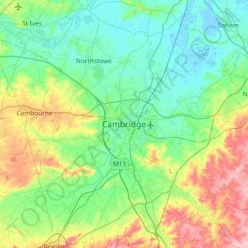
名称:Cambridge地形图、海拔、地势。
平均海拔:33 米
最低海拔:-4 米
最高海拔:130 米
其他地形图
点击地图以查看其地形、其海拔和其地势。
Cambridge
United Kingdom > England > Cambridgeshire
The city, like most of the UK, has a maritime climate highly influenced by the Gulf Stream. Located in the driest region of Britain, Cambridge's rainfall averages around 570 mm (22.44 in) per year, around half the national average, The driest recent year was in 2011 with 380.4 mm (14.98 in) of rain at the…
平均海拔:18 米
Ely
United Kingdom > England > Cambridgeshire
Ely is built on a 23-square-mile (60 km2) Kimmeridge Clay island which, at 85 feet (26 m), is the highest land in the Fens. It was due to this topography that Ely was not waterlogged like the surrounding Fenland, and was an island separated from the mainland. Major rivers including the Witham, Welland, Nene…
平均海拔:4 米
Cambridge
United Kingdom > England > Cambridgeshire
The city, like most of the UK, has a maritime climate highly influenced by the Gulf Stream. Located in the driest region of Britain, Cambridge's rainfall averages around 570 mm (22.44 in) per year, around half the national average. The driest recent year was in 2011 with 380.4 mm (14.98 in) of rain at the…
平均海拔:18 米
Nine Wells
United Kingdom > England > Cambridgeshire > South Cambridgeshire > Great Shelford
平均海拔:20 米
Hemingford Grey
United Kingdom > England > Cambridgeshire > Huntingdonshire > Hemingford Grey
平均海拔:11 米
Hinchingbrooke Country Park
United Kingdom > England > Cambridgeshire > Huntingdonshire > Huntingdon > Brampton
平均海拔:16 米
Ely
United Kingdom > England > Cambridgeshire
Ely is built on a 23-square-mile (60 km2) Kimmeridge Clay island which, at 85 feet (26 m), is the highest land in the Fens. It was due to this topography that Ely was not waterlogged like the surrounding Fenland, and an island separated from the mainland. Major rivers including the Witham, Welland, Nene and…
平均海拔:4 米
Cambridge
United Kingdom > England > Cambridgeshire
The city, like most of the UK, has a maritime climate highly influenced by the Gulf Stream. Located in the driest region of Britain, Cambridge's rainfall averages around 570 mm (22.44 in) per year, around half the national average, The driest recent year was in 2011 with 380.4 mm (14.98 in) of rain at the…
平均海拔:18 米