
Ambalangoda地形图
点击地图以显示海拔。
Ambalangoda
Situated approximately 87 kilometres (54 mi) south of Colombo, it sits on an elevation of 13 metres (43 ft) above the sea level.
关于这张地图
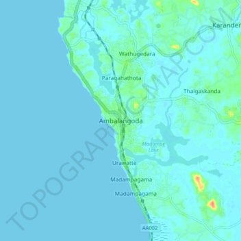
名称:Ambalangoda地形图、海拔、地势。
地点:Ambalangoda, Galle District, Southern Province, 80300, Sri Lanka (6.19891 80.01415 6.27891 80.09415)
平均海拔:4 米
最低海拔:0 米
最高海拔:42 米
其他地形图
点击地图以查看其地形、其海拔和其地势。
Weligama
Weligama (Sinhala: වැලිගම, Tamil: வெலிகாமம்) is a town on the south coast of Sri Lanka, located in Matara District, Southern Province, Sri Lanka, governed by an Urban Council. The name Weligama, literally means "sandy village" which refers to the area's sandy sweep bay. It is…
平均海拔:7 米
Weligama
Weligama (Sinhala: වැලිගම, Tamil: வெலிகாமம்) is a town on the south coast of Sri Lanka, located in Matara District, Southern Province, Sri Lanka, governed by an Urban Council. The name Weligama, literally means "sandy village" which refers to the area's sandy sweep bay. It is…
平均海拔:7 米
Weligama
Weligama (Sinhala: වැලිගම, Tamil: வெலிகாமம்) is a town on the south coast of Sri Lanka, located in Matara District, Southern Province, Sri Lanka, governed by an Urban Council. The name Weligama, literally means "sandy village" which refers to the area's sandy sweep bay. It is…
平均海拔:8 米