
Hindupur地形图
点击地图以显示海拔。
Hindupur
Even in summers, the city experiences lower temperatures compared to the rest of the state due to its high elevation. Every Year, The lowest temperature will be around 3 degrees and highest temperature will be around 11 degrees. Average annual rainfall is 551mm.
关于这张地图
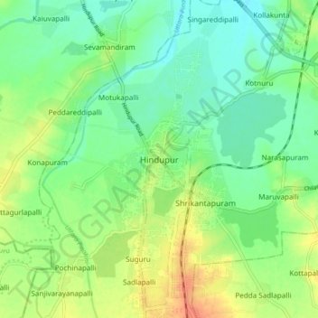
名称:Hindupur地形图、海拔、地势。
地点:Hindupur, Sri Sathya Sai, Andhra Pradesh, 515200, India (13.79061 77.45264 13.87061 77.53264)
平均海拔:623 米
最低海拔:607 米
最高海拔:647 米