
Lockington地形图
点击地图以显示海拔。
关于这张地图
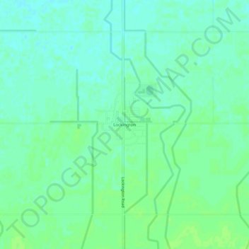
名称:Lockington地形图、海拔、地势。
地点:Lockington, Shire of Campaspe, Victoria, 3563, Australia (-36.29143 144.51609 -36.25143 144.55609)
平均海拔:108 米
最低海拔:103 米
最高海拔:112 米
其他地形图
点击地图以查看其地形、其海拔和其地势。
City of Melbourne
Melbourne's topography is characterized by a diverse landscape that transitions from flat coastal plains to rolling hills and mountainous regions. The city is situated at the northern end of Port Phillip Bay, where the terrain is predominantly flat, facilitating urban development. As one moves eastward, the…
平均海拔:18 米
Melbourne
Melbourne is also prone to isolated convective showers forming when a cold pool crosses the state, especially if there is considerable daytime heating. These showers are often heavy and can include hail, squalls, and significant drops in temperature, but they often pass through very quickly with a rapid…
平均海拔:185 米
Bairnsdale
A comprehensive geological survey of Victoria's Great Dividing Range reveals a distinct north-south alignment in its bedrock, a vestige of the bygone epochs of plate tectonics. This enduring geological framework, coupled with ongoing tectonic activity, contributes to the dynamic topography witnessed in the…
平均海拔:25 米
Grampians National Park
Mount William is known within the gliding community for the "Grampians Wave", a weather phenomenon that sometimes enables glider pilots to reach extreme altitudes of the order of 28,000 ft (8,500 m). This predominantly occurs during the months of May, June, September and October when strong westerly winds flow…
平均海拔:262 米
Melbourne
Melbourne is also prone to isolated convective showers forming when a cold pool crosses the state, especially if there is considerable daytime heating. These showers are often heavy and can include hail, squalls, and significant drops in temperature, but they often pass through very quickly with a rapid…
平均海拔:185 米
Hamilton
Like most of south-western Victoria, Hamilton has a temperate mediterranean climate (Csb). Cold fronts regularly sweep in from the Southern Ocean. Although daytime temperatures occasionally reach into the 30s even 40s during summer, daytime temperatures in the mid teens will often linger into December and are…
平均海拔:196 米
Castlemaine
The Castlemaine goldfields' legendary prosperity raised expectations of Castlemaine becoming Victoria's second city. That is reflected in imposing buildings erected in the town's first few years. Though the rich alluvial diggings were largely exhausted within 15–20 years causing the town's population to…
平均海拔:319 米
Mount Buller
Due to its far south-western location in the alpine region, Mount Buller is more susceptible to cold airmasses which allow it to record some of the lowest maximum temperatures and daytime readings in the country, despite being considerably lower in elevation than other mountain sites to the north-east. On 5…
平均海拔:824 米
Horsham
Horsham's topography is flat, approximately 128 metres (420 ft) above sea level. The central business district (CBD) is laid out in a grid plan south of the train line and is characterised by wide streets and several roundabouts. Firebrace Street, running north–south through the middle of the CBD is one of…
平均海拔:129 米
Frankston
Australia > Victoria > Melbourne
Olivers Hill is the most prominent elevation in Frankston which rises to 55 metres above sea level (180 feet) at its highest point in the suburb. Its origins date to approximately 415 to 360 million years ago. Its base is Mount Eliza Granite dating from the Devonian period, which was covered in lava tuffs in…
平均海拔:40 米
Mount Clear
Mount Clear is characterised by its topography of gently undulating hills flanked by bush and pine plantation forestry. Canadian Creek, on the suburb's eastern border, flows southward.
平均海拔:447 米
Trentham
Trentham is a small town in the Shire of Hepburn and Shire of Moorabool local government area, Victoria, Australia. At the 2016 census, Trentham had a population of 1,180, with a median age of 55 years. Located at an altitude of 700 metres (2,297 ft), the town is 87 kilometres (54 mi) north-west of Melbourne.
平均海拔:702 米
Forrest
Hemmed in by a rising ocean that stabilised about 7000 years ago, the uplifted sedimentary rocks of the Otway Range run from north-east to south-west at an elevation of about 500 metres above the sea. A few isolated peaks reach up to 675 metres, and at many points along this coastline bare mountains and…
平均海拔:212 米