
Concepcion地形图
点击地图以显示海拔。
关于这张地图
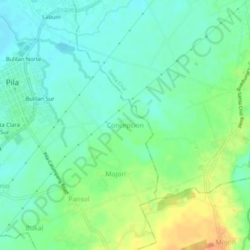
名称:Concepcion地形图、海拔、地势。
地点:Concepcion, Laguna, Calabarzon, 4010, Philippines (14.20791 121.36270 14.24791 121.40270)
平均海拔:17 米
最低海拔:3 米
最高海拔:42 米
其他地形图
点击地图以查看其地形、其海拔和其地势。
Laguna de Bay
Laguna de Bay (Spanish for "Lagoon/Lake of Bay"; Tagalog: Lawa ng Bay, [baɪ]), also known as Laguna Lake, is the largest lake in the Philippines. It is located southeast of Metro Manila, between the provinces of Laguna to the south and Rizal to the north. A freshwater lake, it has a surface area of 911–949…
平均海拔:62 米
Pangil
The municipality is strategically situated at the southern tip of Sierra Madre mountain range (six barangays) and along the eastern margin of Jalajala Peninsula and just west of the northwestern shore of the easternmost major embayment of Laguna de Bay (two barangays). Its narrow strip of territory traverses…
平均海拔:165 米