
Clifton地形图
点击地图以显示海拔。
关于这张地图
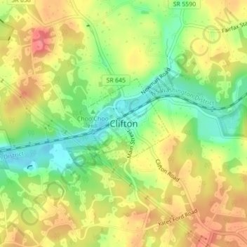
名称:Clifton地形图、海拔、地势。
地点:Clifton, Fairfax County, Virginia, United States (38.77528 -77.39290 38.78517 -77.38023)
平均海拔:87 米
最低海拔:50 米
最高海拔:121 米
其他地形图
点击地图以查看其地形、其海拔和其地势。
Great Falls
United States > Virginia > Fairfax County
Great Falls is located at 38°59′53″N 077°17′18″W / 38.99806°N 77.28833°W / 38.99806; -77.28833 (38.9981653, −77.2883157) at an elevation of 344 feet (105 m). Located on Virginia State Route 7 in Northern Virginia, Great Falls is 15 miles (24 km) west-northwest of downtown Washington,…
平均海拔:90 米