
Luggate地形图
点击地图以显示海拔。
关于这张地图
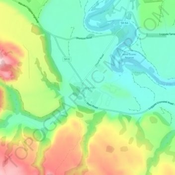
名称:Luggate地形图、海拔、地势。
地点:Luggate, Queenstown-Lakes District, Otago, New Zealand (-44.76567 169.24983 -44.72567 169.28983)
平均海拔:348 米
最低海拔:241 米
最高海拔:536 米
其他地形图
点击地图以查看其地形、其海拔和其地势。
Queenstown
New Zealand > Otago > Queenstown-Lakes District
The town is at a relatively low altitude for a ski and snowboarding centre, at 310 metres (1,020 ft) above sea level at the lake shore, but is nestled among mountains, most notably the scenic attraction of The Remarkables, to the town's southeast. Below the lake lies the deep Kawarau Gorge, and there are…
平均海拔:713 米
The Remarkables
New Zealand > Otago > Queenstown-Lakes District
The area contains a number of beautiful features, such as Lake Alta, a small lake nestled within a natural amphitheatre at the head of a glacial valley (a ‘cirque’) and below the towering Double Cone peaks. There are a number of high altitude walks in the Remarkables Conservation Area including Lake Alta…
平均海拔:1,200 米
Lake Wakatipu
New Zealand > Otago > Queenstown-Lakes District
With a length of 80 kilometres (50 mi), it is New Zealand's longest lake, and, at 289 km2 (112 sq mi), its third largest. The lake is also very deep, its floor being below sea level (−110 metres), with a maximum depth of 420 metres (1,380 ft). It is at an altitude of 310 metres (1,020 ft), towards the…
平均海拔:952 米
Lake Hāwea
New Zealand > Otago > Queenstown-Lakes District
The lake is in the Otago Region at an altitude of 348 metres. It covers 141 km² and reaches 392 metres deep.
平均海拔:864 米