
Little Langdale地形图
点击地图以显示海拔。
Little Langdale
Little Langdale Tarn is a natural tarn within a marshy area of the valley. The area around the tarn is managed by the National Trust and has no public access. It is typical Southern Cumbrian meso-oligotrophic tarn, whilst not at a particularly high altitude itself it has a mean catchment altitude of 520 metres (1,710 ft)
关于这张地图
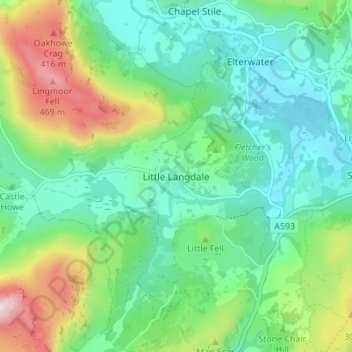
名称:Little Langdale地形图、海拔、地势。
平均海拔:183 米
最低海拔:49 米
最高海拔:514 米
其他地形图
点击地图以查看其地形、其海拔和其地势。
Wharton Tarn
United Kingdom > England > Westmorland and Furness > Hawkshead > Hawkshead Hill
平均海拔:173 米