
Mashpee地形图
点击地图以显示海拔。
Mashpee
Like all towns on the Cape, Mashpee's topography is that of sandy soil, small ponds and inlets, surrounded by the pines and oaks indigenous to the area. The town's shoreline is framed by Waquoit Bay to the west and Popponesset Bay to the east, with several rivers, brooks and small ponds in the area. The town contains South Cape Beach State Park along Dead Neck and Waquoit Bay, and the Lowell Holly Reservation, comprising the land between Wakeby and Mashpee Ponds.
关于这张地图
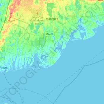
名称:Mashpee地形图、海拔、地势。
平均海拔:10 米
最低海拔:-11 米
最高海拔:72 米
其他地形图
点击地图以查看其地形、其海拔和其地势。