
Burntisland地形图
点击地图以显示海拔。
关于这张地图
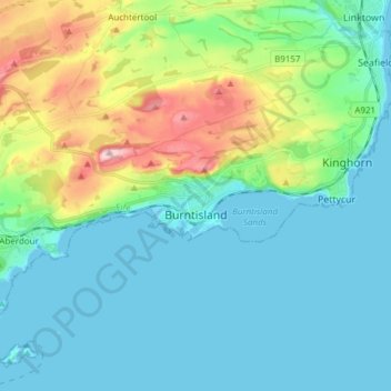
名称:Burntisland地形图、海拔、地势。
地点:Burntisland, Fife, Scotland, United Kingdom (56.02544 -3.28051 56.10157 -3.12860)
平均海拔:49 米
最低海拔:-2 米
最高海拔:216 米
其他地形图
点击地图以查看其地形、其海拔和其地势。
Kirkcaldy
United Kingdom > Scotland > Fife
Towards the end of the 16th century, a detailed assessment on the size of the townscape was carried out. The first estimate of the parish population in 1639 was between 3,000 and 3,200 and around 3,400 by 1691. At the beginning of the 18th century, the population declined. A census by Webster's Topographical…
平均海拔:50 米