点击地图以显示海拔。
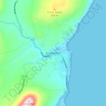
名称:Cushendall地形图、海拔、地势。
地点:Cushendall, County Antrim, Northern Ireland, BT44 0RR, United Kingdom (55.06082 -6.08406 55.10082 -6.04406)
平均海拔:59 米
最低海拔:-1 米
最高海拔:351 米
点击地图以查看其地形、其海拔和其地势。
United Kingdom > Northern Ireland > County Antrim
平均海拔:26 米
平均海拔:97 米
平均海拔:93 米
平均海拔:92 米
平均海拔:111 米
United Kingdom > Northern Ireland > County Antrim > Carrickfergus
平均海拔:28 米
United Kingdom > Northern Ireland > County Antrim > Belfast
平均海拔:170 米
平均海拔:29 米
United Kingdom > Northern Ireland > County Antrim > Loughguile
平均海拔:155 米
United Kingdom > Northern Ireland > County Antrim > Church Bay
平均海拔:10 米
平均海拔:157 米
United Kingdom > Northern Ireland > County Antrim > Randalstown
平均海拔:30 米
平均海拔:258 米
平均海拔:15 米
平均海拔:108 米
United Kingdom > Northern Ireland > County Antrim > Ballintoy
平均海拔:34 米
United Kingdom > Northern Ireland > County Antrim > Aughafatten
平均海拔:171 米
United Kingdom > Northern Ireland > County Antrim > Ballycastle
平均海拔:37 米