
Roan Mountain地形图
点击地图以显示海拔。
Roan Mountain
Roan Mountain is located in northeast Tennessee at 36°11′39″N 82°4′6″W / 36.19417°N 82.06833°W / 36.19417; -82.06833 (36.194219, -82.068417). According to the United States Census Bureau, the CDP has a total area of 6.6 square miles (17.2 km2), all land. The elevation of Roan Mountain near the center of the CDP is 2,550 feet (780 m).
关于这张地图
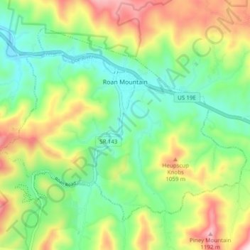
名称:Roan Mountain地形图、海拔、地势。
平均海拔:926 米
最低海拔:760 米
最高海拔:1,210 米
其他地形图
点击地图以查看其地形、其海拔和其地势。
Elizabethton
United States > Tennessee > Carter County > Elizabethton > Elizabethton
The elevation at Elizabethton Municipal Airport is 1,593 feet (486 m) ASL (the highest point of elevation in Carter County is at Roan Mountain with an elevation of 6,285 feet (1,916 m) ASL), and the airport is located on the eastern side of the city along State Highway 91 Stoney Creek Exit. Elizabethton is…
平均海拔:527 米