
Maychew地形图
点击地图以显示海拔。
关于这张地图
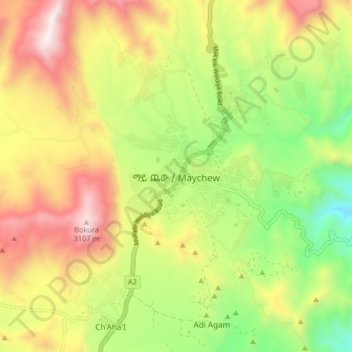
名称:Maychew地形图、海拔、地势。
地点:Maychew, Southern Tigray, Tigray, Ethiopia (12.74412 39.49934 12.82412 39.57934)
平均海拔:2,507 米
最低海拔:1,946 米
最高海拔:3,149 米
其他地形图
点击地图以查看其地形、其海拔和其地势。
Mek'elē
Mekelle (Tigrinya: መቐለ), or Mek'ele, is a special zone and capital of the Tigray Region of Ethiopia. Mekelle was formerly the capital of Enderta awraja in Tigray. It is located around 780 kilometres (480 mi) north of the Ethiopian capital Addis Ababa, with an elevation of 2,254 metres (7,395 ft) above…
平均海拔:2,090 米
Mek'elē
Mekelle (Tigrinya: መቐለ), or Mekele, is a special zone and capital of the Tigray Region of Ethiopia. Mekelle was formerly the capital of Enderta awraja in Tigray. It is located around 780 kilometres (480 mi) north of the Ethiopian capital Addis Ababa, with an elevation of 2,254 metres (7,395 ft) above sea…
平均海拔:2,090 米
Alamata
Alamata (Tigrinya: ኣላማጣ ) is a town in the Tigray Region of Ethiopia. Located in the Debubawi (Southern) zone of Tigray it has a latitude and longitude of 12°25′N 39°33′E / 12.417°N 39.550°E / 12.417; 39.550 and an elevation of 1,520 metres (4,990 ft) above sea level and is located…
平均海拔:1,574 米
Mek'elē
Mekelle (Tigrinya: መቐለ), or Mekele, is a special zone and capital of the Tigray Region of Ethiopia. Mekelle was formerly the capital of Enderta awraja in Tigray. It is located around 780 kilometres (480 mi) north of the Ethiopian capital Addis Ababa, with an elevation of 2,254 metres (7,395 ft) above sea…
平均海拔:2,090 米