
Holehouse Tarn地形图
点击地图以显示海拔。
关于这张地图
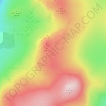
名称:Holehouse Tarn地形图、海拔、地势。
平均海拔:394 米
最低海拔:173 米
最高海拔:568 米
其他地形图
点击地图以查看其地形、其海拔和其地势。
Harter Fell
United Kingdom > England > Cumberland > Ulpha
Harter Fell offers excellent insights into the structure and composition of the Birker Fell formation of the Ordovician Borrowdale Volcanic Group. The fell is dominantly composed of composite andesite lava flows, with autobrecciated upper surfaces developed in some locations. These are often seen in the field…
平均海拔:335 米
Hardknott Pass
United Kingdom > England > Cumberland > Ulpha
The Hardknott Pass stands at a maximum elevation of 393 m (1,289 ft). The road descends steeply at a gradient of 30% (1 in 3) into the Duddon Valley. At the eastern end of the pass is Cockley Beck farm, built in the 1860s and owned by the National Trust. The route from Hardknott leads eastward towards the…
平均海拔:323 米