
Miyako地形图
点击地图以显示海拔。
关于这张地图
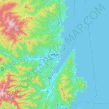
名称:Miyako地形图、海拔、地势。
地点:Miyako, Iwate Prefecture, Japan (39.47958 141.78612 39.79958 142.10612)
平均海拔:223 米
最低海拔:-1 米
最高海拔:1,214 米
其他地形图
点击地图以查看其地形、其海拔和其地势。
Tokyo
The mainland portion of Tokyo lies northwest of Tokyo Bay and measures about 90 km (56 mi) east to west and 25 km (16 mi) north to south. The average elevation in Tokyo is 40 m (131 ft). Chiba Prefecture borders it to the east, Yamanashi to the west, Kanagawa to the south, and Saitama to the north. Mainland…
平均海拔:22 米
Saitama Prefecture
The topography of Saitama Prefecture is largely divided by the Hachiōji Tectonic Line, which runs through Kodama, Ogawa, and Hannō, into the western mountain area and the eastern lowland area. The altitude, highest on the western side, gradually lowers eastward from mountain ranges to hills to plateaus to…
平均海拔:230 米
Yamanashi Prefecture
78% of the prefecture is covered by forests, making it one of the most densely wooded prefectures in Japan. Land cultivated for agriculture is mainly restricted to the lower elevations of the Kōfu basin.
平均海拔:1,019 米
Yokohama
Yokohama has a total area of 437.38 km2 (168.87 sq mi) at an elevation of 5 metres (16 ft) above sea level. It is the capital of Kanagawa Prefecture, bordered to the east by Tokyo Bay and located in the middle of the Kantō plain. The city is surrounded by hills and the characteristic mountain system of the…
平均海拔:23 米
Hakone
Hakone is characterized by its rugged topography, featuring a mix of mountainous terrain, valleys, and volcanic landscapes. Nestled within the greater Fuji-Hakone-Izu National Park, Hakone's elevation varies dramatically, with peaks rising over 4,000 feet and low-lying areas near Lake Ashi, which sits at…
平均海拔:722 米
Ise
Ise is located on the northern half of Shima Peninsula in far eastern Mie Prefecture. The northern part of the city is flat land and faces Ise Bay on the Pacific Ocean. In the south, the land rises to form hills and mountains with an elevation of 100 to 500 meters. Most of the city is within the geographic…
平均海拔:56 米
Tokyo
The mainland portion of Tokyo lies northwest of Tokyo Bay and measures about 90 km (56 mi) east to west and 25 km (16 mi) north to south. The average elevation in Tokyo is 40 m (131 ft). Chiba Prefecture borders it to the east, Yamanashi to the west, Kanagawa to the south, and Saitama to the north. Mainland…
平均海拔:22 米
Kawanehon
Kawanehon is located in north-central Shizuoka, along the upper reaches of the Ōi River, with approximately 90% of the town area covered in forest and mountains. It is bordered to the north by the Japanese Alps, with peaks ranging to 2400 meters. Forests range from Siebold's Beech at lower elevations to…
平均海拔:914 米
Kanagawa Prefecture
Topographically, the prefecture consists of three distinct areas. The mountainous western region features the Tanzawa Mountain Range and the volcano Mount Hakone. The hilly eastern region is characterized by the Tama Hills and Miura Peninsula. The central region, which surrounds the Tama Hills and Miura…
平均海拔:170 米
Kamakura
The Kamakura shogunate era is called by historians the Kamakura period and, although its end is clearly set (Siege of Kamakura (1333)), its beginning is not. Different historians put Kamakura's beginning at a different point in time within a range that goes from the establishment of Yoritomo's first military…
平均海拔:34 米
Tsurugashima
Tsurugashima is located in the geographic center of Saitama Prefecture. Tsurugashima Station is approximately 40 minutes from Ikebukuro Station in Tokyo on the Tōbu Tōjō Line by direct express train. Tsurugashima is located at the tip of the Iruma Plateau, and the elevation is about 30 to 50 meters above…
平均海拔:40 米
Matsudo
Matsudo is located in the far northwestern corner of Chiba Prefecture, about 20 to 30 kilometers from the prefectural capital of Chiba and 10 to 20 kilometers from downtown Tokyo. The western border of the city is the Edo River, which flows from north to south, and most of the city lies on an alluvial plain…
平均海拔:13 米
Sendai
Sendai is located at lat. 38°16'05" north, long. 140°52'11" east. The city's area is 788.09 km2 (304.28 sq mi), and stretches from the Pacific Ocean to the Ōu Mountains, which are the east and west borders of Miyagi Prefecture. As a result, the city's geography is quite diverse. Eastern Sendai is a plains…
平均海拔:185 米
Kanto
The surface geology of the Kantō Plain is the Quaternary alluvium and diluvium. The low mountain vegetation at an altitude of about 500 to 900 m in and around the plain is an evergreen broad-leaved forest zone. The distribution height range of laurel forests is 900 m in Hakone, about 800 m in Tanzawa and…
平均海拔:29 米
Otaru
Otaru is a port town on the coast of the Sea of Japan in northern Shiribeshi Subprefecture. The southern portion of the city is characterized by the steep slopes of various mountains (notably Tenguyama), where the altitude of the land sharply drops from the mountains to the sea. The land available between the…
平均海拔:79 米
Kamakura
The Kamakura shogunate era is called by historians the Kamakura period and, although its end is clearly set (Siege of Kamakura (1333)), its beginning is not. Different historians put Kamakura's beginning at a different point in time within a range that goes from the establishment of Yoritomo's first military…
平均海拔:33 米
Sapporo
Sapporo is a city located in the southwest part of Ishikari Plain and the alluvial fan of the Toyohira River, a tributary stream of the Ishikari River. It is part of Ishikari Subprefecture. Roadways in the urban district are laid out in a grid pattern. The western and southern parts of Sapporo are occupied by…
平均海拔:273 米
Rikubetsu
Rikubetsu is located in southeastern Hokkaido in the northeastern part of the Tokachi Subprefecture. Rikubetsu is divided into two topographical zones by the Tobetsu River, which flows north-south through the center of the region. The western part is a highland plateau and is a center of dairy farming, while…
平均海拔:398 米
Nagano
Nagano (長野市, Nagano-shi, pronounced [nagaꜜno ɕi]) is the capital and largest city of Nagano Prefecture, located in the Nagano Basin (Zenkoji Daira) in the central Chūbu region of Japan. Nagano is categorized as a core city of Japan. Nagano City is the highest prefectural capital in Japan, with an…
平均海拔:828 米
Ohtawara
Ōtawara is located in northeast Tochigi Prefecture in the foothills of the Nasu region. About 50% of Ōtawara is covered by rice fields with about 12% being mountains and forests. The average elevation of Ōtawara is 217.76 meters. Ōtawara is approximately 40 kilometers north of Utsunomiya, the capital of…
平均海拔:276 米
Fujisawa
Fujisawa has three major topographical features: the island of Enoshima to the south connected to the Katase shoreline area by a road bridge, and two rivers, the Hikiji and the Sakai, which run north-south. The Hikiji can be traced from an area designated as a nature reserve park in the city of Yamato and…
平均海拔:19 米
Saitama Prefecture
The topography of Saitama Prefecture is largely divided by the Hachiōji Tectonic Line, which runs through Kodama, Ogawa, and Hannō, into the western mountain area and the eastern lowland area. The altitude, highest on the western side, gradually lowers eastward from mountain ranges to hills to plateaus to…
平均海拔:230 米