
Crestone Needle地形图
点击地图以显示海拔。
关于这张地图
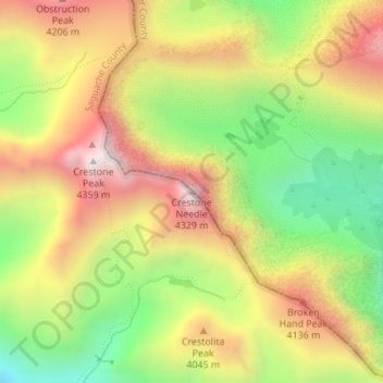
名称:Crestone Needle地形图、海拔、地势。
地点:Crestone Needle, Saguache County, Colorado, United States (37.96467 -105.57673 37.96477 -105.57663)
平均海拔:3,863 米
最低海拔:3,388 米
最高海拔:4,339 米
其他地形图
点击地图以查看其地形、其海拔和其地势。
Great Sand Dunes National Preserve
United States > Colorado > Saguache County
In 1848, John C. Frémont was hired to find a railroad route from St. Louis to California. He crossed the Sangre de Cristos into the San Luis Valley in winter, courting disaster but proving that a winter crossing of this range was possible. He was followed in 1853 by Captain John Gunnison of the Corps of…
平均海拔:2,792 米
Great Sand Dunes National Park
United States > Colorado > Saguache County
In 1848, John C. Frémont was hired to find a railroad route from St. Louis to California. He crossed the Sangre de Cristos into the San Luis Valley in winter, courting disaster but proving that a winter crossing of this range was possible. He was followed in 1853 by Captain John Gunnison of the Corps of…
平均海拔:2,616 米