
Chicagoland地形图
点击地图以显示海拔。
关于这张地图
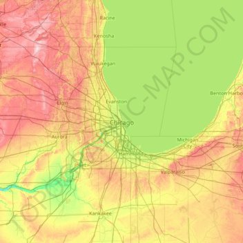
名称:Chicagoland地形图、海拔、地势。
平均海拔:208 米
最低海拔:141 米
最高海拔:358 米
其他地形图
点击地图以查看其地形、其海拔和其地势。
Beverly
United States > Illinois > Cook County > Chicago
Beverly, Morgan Park, Mount Greenwood, Washington Heights, and the City of Blue Island are considered part of the Blue Island Ridge. The prehistoric glacial ridge was once an island in a lake and later part of its western shore. The distinct geological history is the most significant in Chicago, being the…
平均海拔:195 米