
Pioneer地形图
点击地图以显示海拔。
关于这张地图
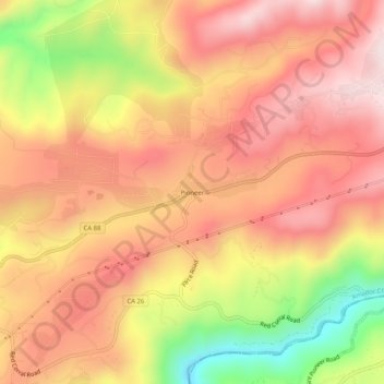
名称:Pioneer地形图、海拔、地势。
地点:Pioneer, Amador County, California, United States (38.41186 -120.59187 38.45186 -120.55187)
平均海拔:888 米
最低海拔:584 米
最高海拔:1,072 米
其他地形图
点击地图以查看其地形、其海拔和其地势。
Jackson
United States > California > Amador County
The area was inhabited by the Northern Sierra Indians, who occupied areas along creeks, spring, and seep areas, including permanent and seasonal drainages, flat ridges, and terraces. Therefore, areas along watercourses are considered likely locations for prehistoric cultural resources. Permanent villages were…
平均海拔:421 米