
Lockport地形图
点击地图以显示海拔。
关于这张地图
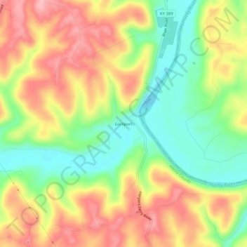
名称:Lockport地形图、海拔、地势。
地点:Lockport, Henry County, Kentucky, 40036, United States (38.41590 -84.98717 38.45590 -84.94717)
平均海拔:200 米
最低海拔:130 米
最高海拔:270 米
其他地形图
点击地图以查看其地形、其海拔和其地势。
Eminence
United States > Kentucky > Henry County
According to the United States Census Bureau, the city of Eminence has a total area of 2.9 square miles (7.4 km2), of which 0.04 square miles (0.1 km2), or 1.70%, is water. The city is located on high ground, with elevations up to 960 feet (290 m), where several watersheds converge. The source of the Little…
平均海拔:274 米