
Walnut Hill地形图
点击地图以显示海拔。
关于这张地图
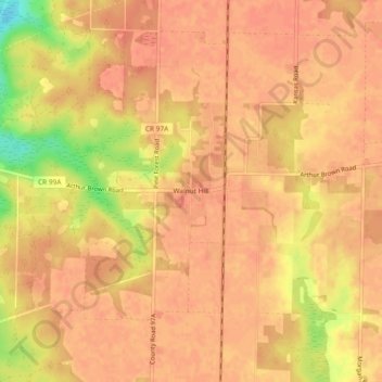
名称:Walnut Hill地形图、海拔、地势。
地点:Walnut Hill, Escambia County, Florida, United States (30.86546 -87.52998 30.90546 -87.48998)
平均海拔:74 米
最低海拔:37 米
最高海拔:83 米
其他地形图
点击地图以查看其地形、其海拔和其地势。
Pensacola
United States > Florida > Escambia County
Pensacola features a diverse topography characterized primarily by its proximity to the Gulf of Mexico and the sheltered Pensacola Bay. The terrain gently slopes upward from the waterfront, resulting in a gradual elevation that provides natural protection against storm surges, making it somewhat less…
平均海拔:21 米
Pensacola
United States > Florida > Escambia County
The land is sloped up northward from Pensacola Bay, with most of the city at an elevation above that which a potential hurricane storm surge could affect.
平均海拔:21 米
Pensacola
United States > Florida > Escambia County
The land is sloped up northward from Pensacola Bay, with most of the city at an elevation above that which a potential hurricane storm surge could affect.
平均海拔:21 米
Pensacola
United States > Florida > Escambia County
The land is sloped up northward from Pensacola Bay, with most of the city at an elevation above that at which a potential hurricane storm surge could affect.
平均海拔:21 米
Pensacola
United States > Florida > Escambia County
The land is sloped up northward from Pensacola Bay, with most of the city at an elevation above that at which a potential hurricane storm surge could affect.
平均海拔:21 米