
Mount Cooper地形图
点击地图以显示海拔。
关于这张地图
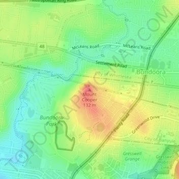
名称:Mount Cooper地形图、海拔、地势。
平均海拔:100 米
最低海拔:73 米
最高海拔:137 米
其他地形图
点击地图以查看其地形、其海拔和其地势。
Templestowe
Australia > Victoria > Melbourne
Gentle, rolling hills extend from east of the Yarra River flood plains, along Templestowe Road (towards the Eastern Freeway) for seven km (4.3 miles), to the north-east. The altitude of the plain above sea level is 50 m, and the topography is subdued and mostly flat; the hills are just below 60 m, the slopes…
平均海拔:66 米
Fitzroy
Australia > Victoria > Melbourne
Fitzroy's topography is flat. It is laid out in grid plan and is characterised by a fairly tightly spaced rectangular grid of medium-sized streets, with many of its narrow streets and back lanes facilitating only one-way traffic. Its built form is a legacy of its early history when a mixture of land uses was…
平均海拔:35 米
Vermont South
Australia > Victoria > Melbourne
In 1966 the Metropolitan & Melbourne Board of Works (MMBW) put forth a plan to construct numerous "package" sewage treatment plants in the valleys of Dandenong Creek and its tributaries. The project aimed to provide adequate sewerage to the catchment before the Dandenong Valley Trunk sewer (DVT) could…
平均海拔:100 米
Mount Dandenong
Australia > Victoria > Melbourne
Mount Dandenong has an oceanic climate (Cfb) with warm summers and cool winters. The temperature usually is 3 - 7 °C (5.4 - 12.6 °F) cooler than downtown Melbourne due to its elevation and distance from the urban island heating effect of Melbourne.
平均海拔:408 米
Scoresby
Australia > Victoria > Melbourne
Scoresby has a weather station which collects data for the Bureau of Meteorology. It commenced readings in 1948 and is situated at Latitude 37.87°S and Longitude 145.26°E at an elevation of 80m above sea level. The site name is the Scoresby Research Institute and its site number is 086104, however it is not…
平均海拔:62 米
Selby
Australia > Victoria > Melbourne
The land around Selby is particularly hilly, as evidenced by the curves in both the road and the railway. The eastern side of the township is dominated by the steep Black Hill, on which there is a reserve. Whilst the topography put restraints on farming it attracted tourists and weekenders. In the 1920s…
平均海拔:250 米