
Finkenau地形图
点击地图以显示海拔。
关于这张地图
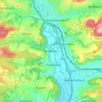
名称:Finkenau地形图、海拔、地势。
地点:Finkenau, Ahorn, Landkreis Coburg, Bayern, 96489, Deutschland (50.21132 10.94994 50.25132 10.98994)
平均海拔:324 米
最低海拔:275 米
最高海拔:425 米
其他地形图
点击地图以查看其地形、其海拔和其地势。
Meeder
Deutschland > Bayern > Landkreis Coburg
Auf der Sennigshöhe (geographische Koordinaten: 50° 21′ 20″ N, 10° 54′ 56″ O50.35555555555610.915555555556) betreibt die Deutsche Telekom AG seit 1965 eine Sendeanlage für UKW-Hörfunk, Mobilfunk und Richtfunk.
平均海拔:398 米